I lost what? Martinez Regional Shoreline and Large Metal Prints

Now, you’re curious and really want to know what I lost: not a camera or lens–my photos! I knew I had an outing to show you, but it didn’t show up on my hard drive. I found it in Lightroom, my photo processing program. The only thing I can conceive that happened is that I accidentally deleted them after I processed the batch. It’s either that or there’s a little gremlin living in my computer and playing jokes on me!

Fortunately, I hadn’t taken them off the SD card yet. The trick, after I downloaded them again, was to transfer my Lightroom edited images back onto the hard drive. You have to fool Lightroom a bit, but I did it. Now, all is well.  Take that gremlin!

I put the effort into this because I wanted to show you how they make metal prints. The tour of this print shop, Large Metal Prints, was fun and educational. As a bonus, they gave us each a free 6 x 9 inch print of one of our images. The next week, I had two more 8 x 12 prints done. You don’t need to put these in a frame, and they come out beautiful. These were the first of my pictures I’ve had printed to put on the walls.

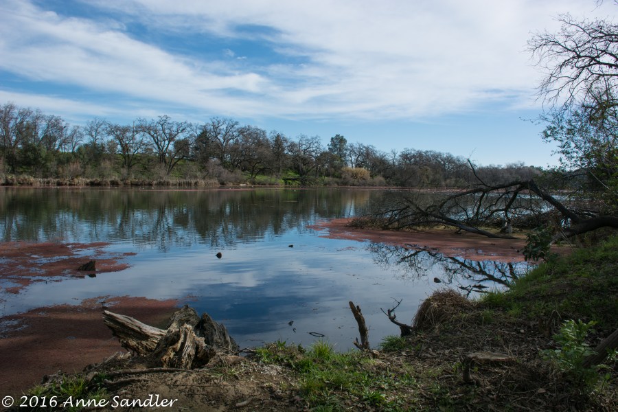
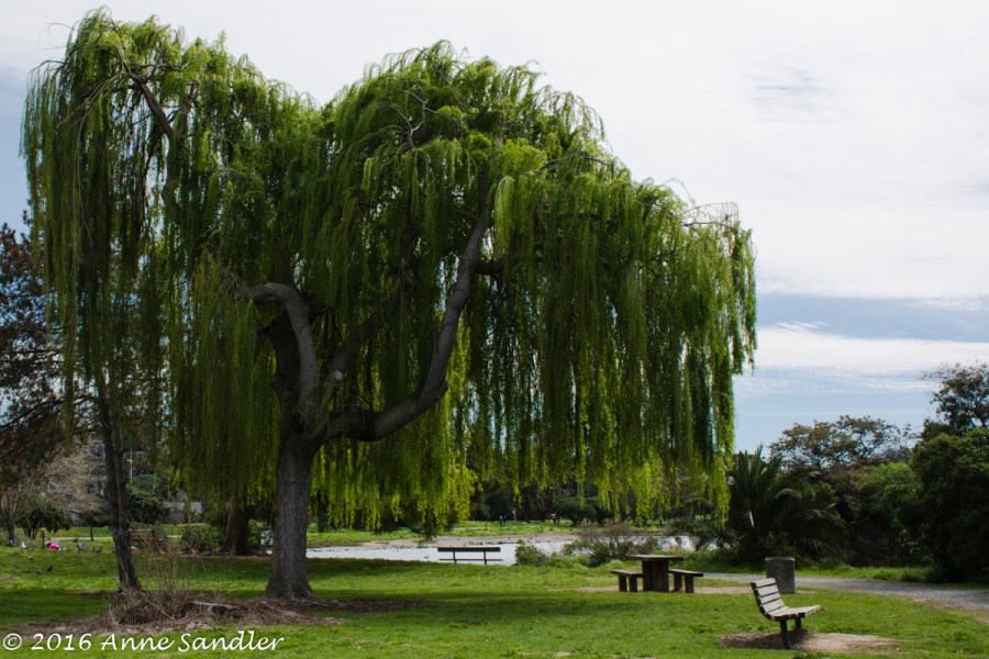
And, before we went to the print shop, we stopped and shot photos at the Martinez Regional Shoreline. It’s a pretty little park with walking paths and bridges. We had just enough time to do a brief walk around and grab lunch.

In the future, I’ll be more careful with my images. If I lose a batch, I might not be so lucky to still have them on my SD card.

After a rain, shoot, shoot, shoot; part 2

Right now in Northern California no one is shooting pictures. We’re experiencing a series of storms. I’m not complaining! My go-to-practice place, Dry Creek, has water past its shore line, and there are flood warnings in place for the rivers and other creeks.

Being stuck inside has its advantages, I’m catching up on a few things, completing this post and giving you exciting news.

For the exciting news: I’m being featured on, Australian photographer, Leanne Cole’s Blog, Introductions post this week. I’ve known Leanne since I started shooting and had the privilege of shooting with her when she visited the U.S. last September. She’s given me advice and watched my progress these 4 years. The post will appear in the States on Monday and Tuesday across the ocean. You can find the post at http://leannecolephotography.com/.

I’ve also submitted an article for the upcoming Dynamic Range digital photography magazine for women in the coming issue. This is a great magazine full of information and beautiful photography. And, you don’t have to be a woman to enjoy it. Check it out!

Now, back to this post’s continuation. Today I have pictures from Schweitzer Grove and McKinley Park. Schweitzer Grove is a 17-acre park tucked into suburbia, and McKinley park is known for its rose garden.  Fortunately, there are people and other flowers at the park. Take a look while I continue to catch up on things.


After a rain, shoot, shoot, shoot: Effie Yeaw,Schweitzer Grove, McKinley Park

It’s sometimes called cabin fever, but for photographers it’s more intense. Since you can’t shoot, you edit, read tutorials or discover new processing programs. So, when, on a recent Tuesday, Marlene and I were the only photographers to partake in Camera Totin’ Tuesday, we took full advantage of the partly cloudy weather.

Our first stop was Effie Yeaw Nature Center in Carmichael. This wonderful preserve houses all sorts of animals, provides educational programs and welcomes photographers. Located on the American River, there is a lot to shoot. On this day, I was looking for deer; but, I was amazed by the area’s beauty after winter rains. And, yes, I did find deer. I couldn’t believe how they let us get so close to them. They know they are protected from human harm, but natural predators are still around. You’ll see more from Effie Yeaw because Marlene and I bought a season pass.

Next we found Schweitzer Grove Nature Area. This is a 17-acre park also in Carmichael that allows dogs to be off leash. It’s quiet and green–a great place to walk babies, dogs or just yourself.

After walking Schweitzer Grove, we drove over to McKinley Park in Sacramento. We were hoping to still see some roses, but there were none. Still, we weren’t disappointed for there were other flowers and people that caught our attention. If you remember, I did a post on this park before and the roses were beautiful. We’ll be back.

What did I learn? My passion for photography grows along with my experience. We have so many beautiful preserves, parks and rivers here in the Sacramento area so you don’t have to drive a great distance to shoot. And, finally, I’m so enjoying the friendships I’ve made with other photographers. Marlene has been my  sidekick for more than a year now, and I do appreciate her willingness to go out with her camera.

It’s raining right now, but it’s supposed to be partly cloudy for our next Tuesday adventure. I know we’re all anxious to get out there and shoot–with our cameras!

This will be a two-part post. There are too many pictures for me to put in one.

You never know what you’ll find: The Sutter Buttes

Tuesdays may be a designated day, but you never know where we’ll end up. We decided to drive around the Sutter Buttes. Formerly known as the Marysville Buttes, this small mountain range is a small circular complex of eroded volcanic lava domes that reside in the flat plains of Sutter County. And, you never know what you’ll come across when you journey around them.

The first stop was Mary’s Chapel. This is a sweet, small chapel and cemetery in Yolo County. It was interesting to walk through and read the head stones. The chapel was closed, but is still used sometimes.

I did this drive a couple of years ago with Laura and we found a farm with unique animals. That farm is still there. This time two other women were amazed. The most curious animal was one that looked like a donkey/zebra! We didn’t know what to call it!

More driving. We found the almond trees had almost lost their blooms and color. The hillsides were deep green and the sky partly cloudy. We took a tour of Gray Lodge Wildlife Area, but didn’t open a window. The mosquitoes were so thick; but, fortunately, Karen’s car window on the passenger side was fairly clean. We did end up catching a sunset near an almond orchard–the perfect end to a fun, adventurous day.


The long, long, long mile: Big Basin Redwoods State Park

How long does it take three photographers to walk a flat one mile loop through the Redwood Trail at Big Basin Redwoods State Park in Santa Cruz County, California? Answer: Almost four hours!

No excuses! It was a beautiful trail through a forest of expressive trees, and there was a lot for me, Marlene and Nicci to shoot.

Coastal redwoods (different from its relative the Sequoia) are found from southern Oregon to central California. Needing the coast weather they extend no more than fifty miles inland. These trees can reach 115 m (377 ft) tall. The bark can be very thick, up to 1-foot , and is soft and fibrous. When freshly exposed there is a bright red-brown color that gets darker as the tree is exposed to the elements. Its roots are shallow, wide-spreading and lateral. Redwoods are naturally resistant to insects, fungi, and fire because they are high in tannin and do not produce resin or pitch.

I remember when my children were young and we camped in a grove of coastal redwoods in Northern California. We went to a campfire program, but I left my flashlight at camp. I was good at walking by starlight, but the forest was so thick, we couldn’t see in front of us. Once I found a family who was walking back to the same campground, we followed them. I’ve never assumed that I could walk via moon and star lights again!

As for what lessons we learned:

  1. Always carry in your tripod. The forest is dark!
  2. Use a fast lens.
  3. Pack a lunch. Don’t count on a fast visit. Fortunately we brought snacks, and the cafe had a limited amount of lunch items.

Take a look at why it took us so long to walk that mile!

Failure, fun, fantastic: Auburn

They say we learn from our mistakes and Marlene, Karen and I did. Following a suggestion, we went to Lake Clementine near Auburn, but didn’t get to the right place. By the time we found the area where we could practice with our ND filters, the sun was too high–A fact we learned later. That was the failure, but we did learn. When using ND filters, you need to be out early morning or in the evening!

Fun, we did have. We drove on to Auburn where we had lunch, walked and took pictures. We went into the old courthouse and were allowed to take pictures anywhere we liked. It was fun.

Fantastic, happened when we started looking for a place to shoot the sunset. The place a restaurant owner directed us to, wasn’t suitable, and the sun was setting lower in the sky. Off we drove until we came to a private home with acreage, trees and a small pond. This would be perfect. With a lot of coaxing from me, (Okay, I strongly suggested that Karen get out of the car and ask the owners if we could park in their driveway and shoot the sunset at the property. I was driving.) Karen and Marlene bravely pressed the button on the gate code intercom. It paid off. We were allowed to park in the driveway and shoot the sunset.

So, on this great outing, failure led to fun, and more fantastic shooting opportunities. Next time we go to the area near Lake Clementine, we’ll do it earlier in the morning. It’s a small hike to the waterfall, and we’d all rather do it in cooler temperatures and when the sun isn’t so high.


Mustard and Alpacas: Napa California

We expected wineries but photo buddy Karen took us on a special tour of Napa and Napa Valley. We didn’t see the touristy Napa Valley as described here, taken from the Napa Valley website: “More than 400 wineries dot the fertile soils of Napa Valley, one of the world’s premier viticultural regions. But wine, as visitors quickly discover, is only the beginning. Lavish resorts and top-rated chefs work alongside the farmers who tend this land: the result is something understated and exceptional.”

We saw the real Napa Valley. During our day we saw Lake Solano Park, Monticello Dam, rolling green hills, mustard tucked in between rows of vineyards, livestock grazing, alpacas and where her husband’s family ranch used to be. And we visited Napa City towards the end of day for some fantastic lighting.

Let’s see, what did I learn? I discovered the difference between llamas and alpacas, and again took the ultra wide lens out for a spin. So take a look at the Napa we saw on our recent visit with Karen.

Do you know the way to San Jose? Livermore & Sunol Regional Wilderness Park

My trip to San Jose, for my yearly vision board session, with Marlene was going according to plan. We stopped in Livermore to shoot the sights and eat lunch.

While Livermore is nationally known as the home for the Lawrence Livermore National Laboratory, it’s a small, lovely town nestled in rolling hills. We walked around Historic Downtown, and I thoroughly enjoyed the way it was designed.

Next we stopped at the Sunol Regional Wilderness Park. I always wanted to get off the freeway to see what was hidden in the hills as I would go to San Jose, but never took the time. This was the time! It’s a beautiful area and now green because of our recent rains. There are many parks, lakes, etc. for residents to enjoy. Our stop was at the Sunol Regional Wilderness. Located in Alameda County and near the town of Sunol. It was primarily ranch land, and today cattle still graze in some areas. We enjoyed shooting in this beautiful park; however, our adventure went awry when we left.

I have no idea what got into me. Maybe it was the Greg Morris influence, but I saw that Calaveras Road continued on into Milpitas. I had my trusty GPS with me. And Marlene didn’t say “No, I don’t think it’s a good idea to go that way!” So off we went on a joy ride that would include mostly hairpin turns on an extremely narrow road. Not knowing the road, I was going around 18 to 25 miles per hour and the drivers coming the other way were cruising at about 40 miles per hour! Worse, remember those hairpin turns? They came around so fast and had to break when they saw me. Moving over wasn’t so much of an option with a shear drop on one side and a mountain on the other. At one point, Marlene suggested that the car came with a horn to use as a warning device.

We made it. But we weren’t able to pull over and take pictures of the beautiful scenery that included the Calaveras Reservoir. So, we made mental pictures, and I can’t show them to you. You can click on the link to see someone else’s images!

Going off plan proved adventurous, somewhat nerve racking at times, but gave me something to write about.


What’s in a name?: Capay Valley

Well, what is in a name? Everything! As a former journalist and copywriter, I know that a name is very important. When you name a new company, it has to fit the personality and style of the group. It also has to appeal and suggest a benefit to the potential customer. So here we are with our newly formed Tuesday group, and still no name.

Now you’re thinking, why do they need a name. It’s simple, for the reasons above. After weeks of thinking, bantering and laughing –mostly because I threatened not to let them go home at the end of a long day shooting–we have a name! It is Camera Totin’ Tuesdays. I won’t go into what other choices we came up with, at least not in print. It’s amazing how silly you can get on Diet Coke, tea and water! Boy, do we know how to have fun.

And the name’s working already. We have two women wanting to journey with us when they can. Sometimes we know exactly where we’re going, and other times we just drive and see where the road takes us. We are secure with a GPS and a “Home” button.

This journey took us into Capay Valley. Karen was our guide since she knew the area. This valley is a mostly rural area northwest of Sacramento in Yolo County. Dotted with small towns, it was beautiful with rolling hills and great color. It’s amazing what a little water can do. With mostly farms, the culture is quite different from urban Sacramento and its suburbs.

I think the name Capay has something to do with American Indian culture since a few different tribes have inhabited the valley. I wish I could say for sure because names do tell tales!


Fun day, snow day: Donner Lake, CA

Let’s see: boots, check; flannel lined leggings, check; three layers on top, check; knitted head scarf, check. I’m all ready for a fun day of shooting in the snow at Donner Lake.

Marlene, Linda and I went off early one Saturday morning to get ahead of the weekend crowds. However, to our surprise, there weren’t a bunch of people on the Donner Lake roads. It was beautiful with temperatures in the high 50’s (Fahrenheit) and sunny. What fun.

The reality is that we drove around the lake, drove to the mountain top and drove into the nearby town of Truckee. Yes, we did get out, walk around and shoot. But, we didn’t hike. Still, the thrill of stepping into a foot of snow was there. At one time, I did fall, butt down, into the fresh icy snow. When I fall, so do my two cameras hanging from a sling. I got up and wiped them down with a towel I brought along. They didn’t suffer. Neither did I.

Since this was my first time shooting in the snow, I read tutorials. Of course they contradicted each other! That’s the frustrating about learning photography, there are many ways to achieve the same end. So, I decided to bracket my shots. At least one of the three would be good, right? When I uploaded them to my computer, I decided that the original exposure shot was the correct one. They did need some processing in Lightroom to tone down the white and, sometimes, blue of the snow.

And, we met a few nice people who were more than willing to chat. I get it now Greg! What did I learn from this experience? I discovered that whatever your physical capabilities you can have fun in the snow. Just make sure you’re covered for whatever weather Mother Nature brings–boots, hat, enough clothing layers and good friends.