On the road again: Bodie and Mono Lake, California, final chapter.

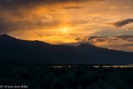
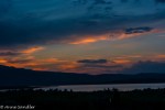
Catch a breath, relax and gaze. That’s one way to take in Mono Lake. Photo buddies Marlene, Laura and I took it in with our cameras. We were there as part of our weekend trip to the ghost town Bodie.

Mono Lake is a large, shallow saline soda lake 8.321 miles long. It’s at least 780,000 years old and is among the oldest lakes in North America. While we enjoy its beauty, migratory birds call it home for a while and brine shrimp swim its waters.

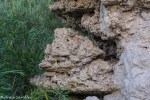
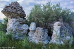
You can see Tufa Towers as you walk down to the lake. These salt towers are formed because having no outlet, trace amounts of salts and minerals brought into the lake by freshwater streams have accumulated over the centuries. This resulted with Mono Lake having a salinity two to three times the Pacific Ocean. Tufas are the result of the combination of minerals in fresh and salt water. They take on all sorts of shapes and various neutral colors.

The images you’ll see in this post are of sunset and sunrise (Only Laura can get me to wake up at 4 a.m.) when the lake looks most beautiful. Just catch a breath, relax and look.

An amazing find: Rush Ranch, Solano County, California

The best things are the ones you don’t expect. And, I didn’t expect Rush Ranch to be so beautiful and fun to shoot. We went there after we visited the Suisun Wildlife Rescue Center. Photo buddy Laura suggested this and Marlene and I were agreeable. Oh, did we have fun, and we didn’t even take any of the nature paths. We stayed and shot old equipment, etc.

Rush Ranch is a working ranch, with cattle and sheep grazing under a wildlife habitat management program. Prior to its purchase by the Solano County Farmlands and Open Space Foundation in 1988, this ranch was owned by the Rushes (a pioneer family).

Now it is open to the public with three hiking trails that take you through different ecosystems. These are the trails we didn’t have time to walk. So we need to go back. Who knows what we’ll see, especially when we don’t expect to.

Meanwhile, enjoy these images from the immediate property.

Deja vu: Mossy trees and mustard, Lake San Antonio, Monterey County, California, part 2

Do you remember the mossy trees and mustard that I went all the way to Napa Valley to shoot? Well, I found the trees in our campground and the mustard in the countryside here at Lake San Antonio.

It’s amazing how much I’ve learned through photography, and I don’t mean learning the art. I’ve studied birds, flowers and trees! So during this trip I had the opportunity to educate my husband in the flora of the area. Sadly, because the lake is so low now, there wasn’t the opportunity to see many water fowl. There were plenty of turkey vultures though.

In addition, I became acquainted with the various stages of the dreaded fox tail from beautiful to mowed down so they stick in your socks and dogs paws. All weekend I picked fox tails from Gem’s hair, checked his ears and made sure he was tick free. The little guy was happy to be home.

In this post, I’ll give you the campground tour including the mossy trees. You’ll have to wait for the next post to see the mustard.

Chasing windmills: Montezuma Hills, California

Have you ever chased windmills, you know the big white ones? Photo buddy Linda and I went out the day before a scheduled Meetup to catch the scenery, windmills, moonrise (which I didn’t get a good shot of) and sunset. Tall order for tall windmills!

We got to the area an hour later than the Meetup group was scheduled for the next day. Well, an admission, we didn’t get to the appointed area until we saw it on the way home. Typically when we meet with the Exploring Photography group, we enjoy a meal together and our organizer gives us directions and tips on where we should go to shoot. Not having these directions, we sort of got lost, but had a great time.

We stayed mostly on Montezuma Hills Road, stopping whenever we could after seeing something worth shooting. The area is farm country with windmills sitting in the pasture land. It’s not unusual to see windmills among the cows and farms.

I can’t say that the images I’m going to show you are my best, but they were the best I could do without an ND filter system. I wanted to get those giant windmills in slow shudder, but the sun was too bright. And by the time we got back from dinner, we almost missed the sunset. By the time we were on our way home, we were tired and thoroughly enjoyed chasing the windmills.

Discovering Northern California: Downievelle

It was an adventure back in time. With a population of 282 (the 2010 census) Downieville, the former gold rush town, now caters to summer visitors. However, photo buddies Marlene and Greg, and I were there last week. I can believe that they are a seasonal vacation spot because all the restaurants were closed and set to reopen for the season. I still don’t have any idea when the season starts!

Fortunately, the grocery store was open, had a microwave and allowed me to use it after I purchased a frozen rice dish. The small town hospitality came through. Sure I could have a glass of ice with my bottled diet coke–no extra charge for the cup! As we shot photos on the main drag, people passing knew each other. One of the residents explained that when they want to dine out, they go to the nearest town. It’s a simple life.

I’ll show you pictures of Downieville and give you more history in my next post. In this post, I’ll show you the sights on our way to the town and on the way back. You’ll be transported back in time along the North Fork of the Yuba River.

A full day of beauty: The UC Davis Arboretum, the people

I love street photography, but I’d rather it was candid. I know that’s the more difficult way to go, but it tells a better story. Fortunately, it was a weekend and the people were out enjoying the weather and beauty of the UC Davis arboretum. There were families, students, runners, cyclists, and many more. I’ll tell you about each image in the gallery. If I have room, I’ll also put in some odds and ends that I either forgot or didn’t fit into my three categories.

Some street photography!

A full day of beauty: The UC Davis Arboretum, the landscape

I’d like to think that the arboretum put on a fancy dress just for Laura, Marlene and me when we visited last week. However, I think we were lucky to catch the area in its glory. Spring had come, and beauty was everywhere, wildlife was out and people were strolling along the creek.

In my last post I explained that the arboretum is a 100 acre park that borders Putah Creek. About 17 gardens have been planted along the creek, giving variety to the eye and much to shoot for photographers. I also promised a three-part post with the second showing the arboretum’s landscape and the third–the people.

In this post, I’m showing you the landscape as seen through my eyes. I’m not going to caption these images since there are a lot of them. So, enjoy the beautiful creek, trees and shrubs. After all they dressed up just for us!

New year, new project: Marina Bay Trail, Richmond, California

I never wanted to get into portriat photography, but today Gem, my dog, was my subject and he did a great job of trying to sit still and look at me. I’m only on day 4 of the 365 challenge and was shooting Gem because I didn’t get out. But, I was learning. I’ve made a secondary challenge to shoot most of my daily photos on manual, and Gem had to be very patient while I was doing the learning curve! I was so excited that I finally managed to shoot him on manual, but he didn’t high five. That’s okay, he got his treat anyway. I’m sure there will be more shots of Gem throughout the year.

Yesterday, I went on an all day Exploring Photography Meetup to Richmond and had to process one of the images so I could post in the challenge group. I posted a sunset, which, as it turns out, wasn’t the best of the sunset shots. But, day 3 was covered. I’ll show you part of the day’s images in this post and finish it up in the next.

The Marina Bay Trail is somewhere between 3 – 4 miles along the Richmond shoreline. They have a yacht club, marina, condos, etc. It’s in stark contrast to the city of Richmond. I think I’ll show you the grounds in this post and the birds in the next.

I’m getting out to shoot tomorrow so Gem won’t have to model.

A birding shoot gone wrong: Tundra swans near Marysville, California

I don’t know how I did it! I even told my photo buddy Liz to shoot between F/9 – F/13. So why did I have my camera at F/5.6?

Of course I didn’t realize it. I thought I had closed the aperture to get the best depth of field. It took me a few days to find the time to figure things out. I remember thinking something was wrong with the lighting and increased my ISO. After all it was overcast. I guess we learn from mistakes, and I’m sure this isn’t the last I’m going to make!

We did have a good time shooting the swans. There were a lot of them, and we were amazed at how they just settled down on the farm lands. Imagine waking up to look out at the beautiful Tundra Swans. Here are some images I thought were salvageable and okay.

Back from Death Valley with more to show you, part 4

You may have heard in the news that after a 3-year drought, California is experiencing a severe wind and rain storm. With that being a prominent concern, we dead headed from Death Valley and drove 11 hours to home yesterday to avoid getting caught in 60 mph winds that hit last night.

But, I still have so much more to show you. Death Valley is full of surprises and one of them is Scotty’s Castle. It’s called Scotty’s Castle because Scotty was the person most associated with the vacation home of millionaires Albert and Bessie Johnson. Scotty and Albert’s relationship was born out of a swindle (on Scotty’s part) and went on to become a friendship that would last Albert’s lifetime. People came from all over to meet Scotty and hear his tall tales. The Johnsons rented rooms and had private guests. The tour guide told us that when friends came, Bessie would play their favorite song from the clock tower as they were approaching. More of the history can be found at the two links I’ve provided.

My next post will show you the Devils Corn Field, Sand Dunes and Mosaic Canyon.

Now for the Castle images.