Back to the 18 – 55: Sutter Creek, California

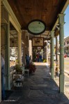
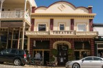
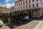
Old, quaint, touristy, and surviving are just some words to describe Sutter Creek in the California gold country and Amador County wine area. I say surviving because you used to have to go through the town as you drove highway 49. Now there’s a bypass so drivers don’t get bogged down in the town’s traffic.

From the town’s website: A wonderful balance of old and new, today’s Sutter Creek maintains its Gold Rush facade while catering to the wants and needs of visitors from around the world.Shop, dine, slumber, stroll, wine taste, and enjoy the quaint atmosphere of Amador County. Sutter Creek, the jewel of Amador County & the Gold Country,  is steeped in history being born of the California Gold Rush and nurtured by the deep rock gold mines of the 19th & 20th centuries. 

I wasn’t as impressed with Sutter Creek as I was by Downieville. But then, we were able to buy lunch in this town! Sutter Creek was more commercial, not catering to any season. But it is surviving.

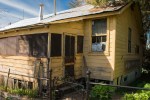
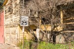
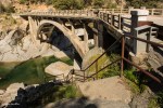
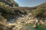
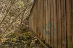
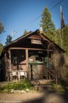
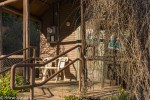
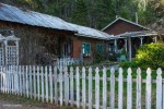
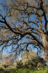
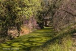
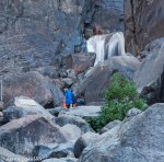
Here are some images.

Discovering Northern California: Downievelle

It was an adventure back in time. With a population of 282 (the 2010 census) Downieville, the former gold rush town, now caters to summer visitors. However, photo buddies Marlene and Greg, and I were there last week. I can believe that they are a seasonal vacation spot because all the restaurants were closed and set to reopen for the season. I still don’t have any idea when the season starts!

Fortunately, the grocery store was open, had a microwave and allowed me to use it after I purchased a frozen rice dish. The small town hospitality came through. Sure I could have a glass of ice with my bottled diet coke–no extra charge for the cup! As we shot photos on the main drag, people passing knew each other. One of the residents explained that when they want to dine out, they go to the nearest town. It’s a simple life.

I’ll show you pictures of Downieville and give you more history in my next post. In this post, I’ll show you the sights on our way to the town and on the way back. You’ll be transported back in time along the North Fork of the Yuba River.

A full day of beauty: The UC Davis Arboretum, the people

I love street photography, but I’d rather it was candid. I know that’s the more difficult way to go, but it tells a better story. Fortunately, it was a weekend and the people were out enjoying the weather and beauty of the UC Davis arboretum. There were families, students, runners, cyclists, and many more. I’ll tell you about each image in the gallery. If I have room, I’ll also put in some odds and ends that I either forgot or didn’t fit into my three categories.

Some street photography!

A full day of beauty: The UC Davis Arboretum, the landscape

I’d like to think that the arboretum put on a fancy dress just for Laura, Marlene and me when we visited last week. However, I think we were lucky to catch the area in its glory. Spring had come, and beauty was everywhere, wildlife was out and people were strolling along the creek.

In my last post I explained that the arboretum is a 100 acre park that borders Putah Creek. About 17 gardens have been planted along the creek, giving variety to the eye and much to shoot for photographers. I also promised a three-part post with the second showing the arboretum’s landscape and the third–the people.

In this post, I’m showing you the landscape as seen through my eyes. I’m not going to caption these images since there are a lot of them. So, enjoy the beautiful creek, trees and shrubs. After all they dressed up just for us!

A full day of beauty: the UC Davis Arboretum

When you’re in or near Sacramento, California, you’ve got to visit the UC Davis Arboretum. Laura, Marlene and I walked the approximate 5 – 6 miles around the area, stopping for lunch. Even though I carried my cameras on a two-camera sling and everything else in a photo vest, my back was protesting during the last third of the trip.

The arboretum is a 100 acre park that borders Putah Creek. About 17 gardens have been planted along the creek, giving variety to the eye and much to shoot for photographers. I don’t know whether I’m just getting better at my craft or whether the gardens were beautiful even though it wasn’t spring yet; but, I do have a lot of photos to show you. So I’ll do it in three parts. Tonight I’ll show you the wildlife, next the landscape and finish up with the people.

The arboretum wildlife consists of birds, turtles and water fowl. And, they were pleantiful when we were there, especially the egrets. I’ve always seen one or two at the arboretum, but there were more that Sunday. No more words–here are the images.


The 365: Old Sacramento with Sharon

I had the pleasure of spending most of the day with my friend Sharon from Los Angeles before she went on to San Francisco last week. I picked her up at the airport after my Toastmasters meeting, we went to lunch and then headed to Old Sacramento. Now I would never had pulled out a camera before the 365 day challenge, but I did. After feeding the parking meter, I explained the 365 challenge to her. Not only was she okay with it, she was pointing out interesting things to me.

Old Sacramento is an area, located on the Sacramento River, containing quaint shops, old architecture, a train station, a few museums (most notably the Railroad Museum).

I enjoyed that day with Sharon, not only catching up with her, but realizing that I will probably pull my camera out from now on–365 challenge or not.

This challenge is amazing. I’m learning more than I thought I would and also found the support of a long-time friend.

A fun and learning experience: Yosemite, part 3

Two days is barely enough to take in the beauty of Yosemite, but that’s all we had. So we packed as much in as we could.

My last lesson here, was that I needed to get a neutral density filter to capture smooth water. I waited until we got to our final destination within the park–Happy Isles to try to get the water as smooth as I could. It was shady there, and there was enough water to work with.

We also went to the Lower Bridalveil Falls and the church. Tired, we left the park before sunset and ate dinner in Manteca. The Thai food was delicious especially since I was tired of eating meatloaf (for lunches and dinner)! Laura dropped me off at about 9:30 p.m., and I went directly to bed. I know she began editing her photos when she got home.

Here are the last images of Yosemite.

A fun and learning experience: Yosemite, part 2

Live and learn–you’ve heard that before. So far during my excursion to Yosemite I’ve learned to get those heat pads for shoes and pockets when shooting during the dawn patrol.

My second lesson was that I chose the right person to travel and shoot with. Laura kept me moving–even after I called myself a wimp and she agreed. We had a lot of fun together, and she pushed me forward in my photography. There will be more on that subject in part three. I have been fortunate in my photography journey to receive help from fellow photographers, amateur and professional alike. Moreover, Laura knows this park and the right places from which to shoot.

In today’s post you’ll see Foresta. It was part of the area burned a few years ago, but the two barns remained and we were able to go into one. We also went to Stoneman Bridge and then the “fire fall” area. Remember, there was no water falling, but we did get to see how the “fire” effect was done. So we had fire but no fall!

A fun and learning experience: Yosemite National Park

California is a true wonderland when it comes to visiting National Parks. So many are within a 5-hour drive. Yosemite is one of them. I’m so glad that I saw Yosemite before the drought.

Photo buddy Laura and I went there for a couple of days to catch the “fire fall effect.” Once a year when the sun is in the right place and water is in abundance you can get the “fire fall” effect just like the old days when they used to drop fire over the falls. Even though it rained the week before, there was not a drop of water coming down the mountain. The drought was evident elsewhere too with the meadows dry and brown. I remember green meadows.

Our journey began with our first night outside the park. We light painted a gazebo across from the lodge. Then at 4 a.m. the next morning we went into Yosemite to catch the sunrise from the Swinging Bridge. This will be a three part post. Today’s post will take you though first evening and morning at Yosemite. We waited on Swinging Bridge for the sunrise. It was an experience!


Dial “M” for manual, mossy trees and mustard: Napa Valley, California

Napa Valley is the place to go to find mossy trees and mustard plants, and shoot on manual. It’s actually where I had a significant breakthrough on shooting manual. I think I have a smidge more to learn, but I’m mostly there.

Known for its wineries and beauty, Napa Valley was the target for our Exploring Photography Meetup group a couple of weeks ago. We met for lunch and then went off in search for mossy trees and mustard. We had four in our car, and without written directions, we were relying on memory to follow the verbal directions given us. Of course that didn’t work, so we just followed our noses!

Before lunch, we did stop at Turnbull Winery to look at their Ansel Adams exhibit. We took the time to shoot what we could of the winery.

After lunch, we found mustard (a yellow wildflower that seems to grow well under the barren grape vines) accidently while driving to where we thought we remembered the mossy trees to be. It was a small and accessible field–a great find.

Luck followed us to the mossy trees also. These trees had lichen hanging from the barren branches, giving the trees an eerie look. We saw the trees but then went up to the Chappellet Winery and was quickly dismissed back down the road! We did stop to shoot the trees.

Now on to the mossy trees and mustard, both shot in manual!